
Landmark Deepsea Environment Moorings Successfully Deployed in the Cook Islands
Historic Deployment of Environmental Moorings
The Cook Islands has reached a significant milestone with the first-ever deployment of three deep-sea environmental monitoring mooring arrays north of Aitutaki (figure 1). Conducted under approved exploration licences, this initiative was a joint effort between Moana Minerals Limited (MML) and Cobalt Seabed Resources Limited (CSR). Expedition MMLCSR03, led by Chief Scientist Michael Wright from ERIAS Group, an environmental and social impact assessment consultancy. The expedition took place from 16–23 February aboard MV Anuanua Moana, a research vessel operated by Kiva Marine. The deployment was closely monitored by three SBMA inspectors, while four independent Cook Islands observers gained firsthand insights into the process and its significance for ocean research (figure 2).

Figure 1: Location of Deployed Environmental Moorings named MA_001, MA_002 and MA_003
The Importance of Environmental Moorings
Placement of environmental moorings are leading practice worldwide. Each mooring is anchored to the seabed using a heavy weight and suspended vertically via floats. These moorings are usually custom designed as part of wider environmental baseline studies and are equipped with various instruments to collect long-term data on marine conditions, including:
Variations in ocean temperature and salinity
Rates of natural sedimentation and associated turbidity (cloudiness)
Strength and direction of ocean currents
Natural and existing levels of sound
Emphasising the significance of research and data collection “These moorings will play a vital role in establishing baseline environmental conditions, supporting ongoing scientific research and informed decision-making in the sector,” explained SBMA Knowledge Management Officer and Inspector for the expedition, Tanga “TJ” Morris.


Figure 2: Science team, vessel crew, Inspectors and observers during pre-briefing
Image supplied by: Moana Minerals Limited (MML)
Deployment Details
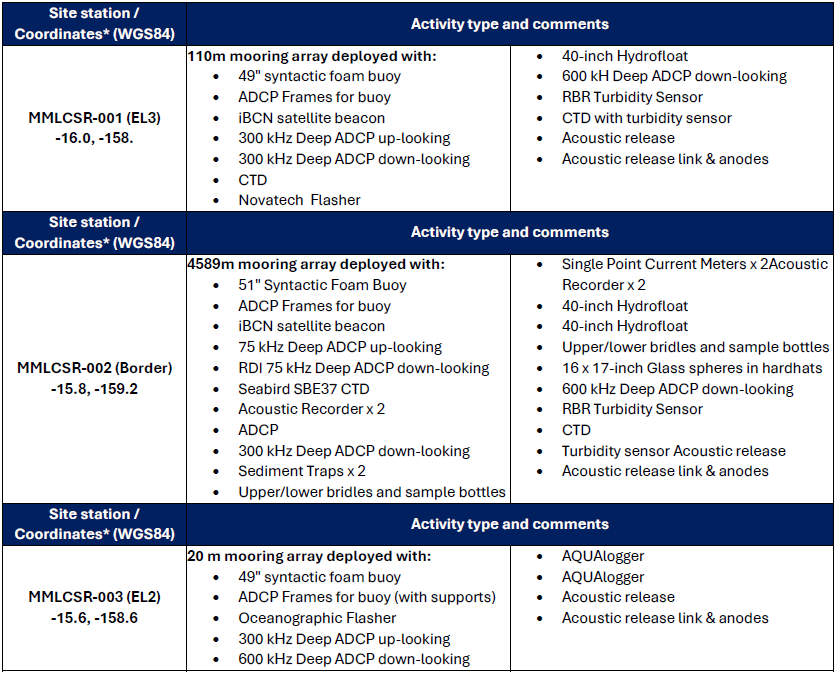
Three moorings were deployed (table 1). The longest mooring rises ~4600 m from the seabed (to ~ 500 m below the sea surface) and was deployed at the border of MML and CSR licence areas. It holds a greater number of instruments that are used to study most of the water column. The two shorter (~110 m and ~20m tall) moorings are focused on the near seabed (benthic) and overlying seawater environments.
Table 1: Environmental Mooring Details (*To 0.2°)
Firsthand Experiences from Observers
Policy Analyst, Office of the Prime Minister and Observer, David Pori expressed his firsthand experience: “The seven-day ocean science expedition on Anuanua Moana to deploy three environmental mooring arrays and collect bathymetric data and two box core samples of the seabed is an opportunity for every Cook Islander to experience. The relationships and connections I formed with the crew, scientists and observers onboard speaks to the trust, resilience, and comradeship of working together as a team. Understanding more about our ocean environment by collecting data is the best way we can make evidence-based informed decision making for our future.”
Climate Change Youth Ambassador, Charlene Akaruru from Climate Change Cook Islands, Office of the Prime Minister and Observer stated that: “My experience aboard Anuanua Moana as an observer was fascinating and companiable. It was fascinating learning about the deep ocean which for me is a new frontier having worked with Climate Change Cook Islands and alongside NGOs. Secondly, understanding the contrasting functions of the instruments installed on the three mooring arrays, these instruments capture data on ocean turbidity, ocean salinity, ocean temperature and other useful data at depths of 5,000+meters. Lastly, observing hydrographic surveying processes, a significant role that involves mapping of the seabed, creating triangulation points, and charting courses ensuring work is done within licensed areas. Surveying using tools such as hydro phonic pings, QGIS software, and Qinsy programming. So much to learn and understand and I really appreciate the first hand and hands-on experience. As the captain of the vessel says, "this ship is like a floating university".
Local Fisherman and Observer, Metua Mitchell further commented: "Experiencing this expedition firsthand has given me a deeper understanding of the work being conducted in the waters of the Cook Islands. Given the sensitivity of seabed mining in our country, it is crucial to share knowledge honestly, ensuring our people understand its purpose and impact. The deployment of moorings, equipped with instruments to monitor environmental changes, raises important questions: How will this affect fisheries and marine life migration? Will sediment plumes disrupt our reef ecosystems? And is the licensed area sufficient to yield accurate data? As Pacific Islanders, our connection to the ocean is vital. The findings from this expedition must be shared transparently, so our people can make informed decisions about the future of our waters."
Data Collection and Future Research
The moorings are expected to remain in place for about a year before another expedition retrieves them, downloads the data they contain, and redeploys them. The results will be integrated with other data to create a more complete picture of the ocean. This includes data collected from specialised sensors mounted on seabed samplers and research completed by marine scientists throughout the region.
By law, in the Cook Islands, all environmental data—including this data—will be placed in the public domain once processing and reporting are complete.

Image supplied by: Moana Minerals Limited (MML)
Regulatory Oversight and Compliance
As part of its regulatory function, SBMA Inspectors closely monitored the deployment operations to ensure compliance with agreed workplans and standards. Reflecting on his experience, SBMA Inspector Andrew Ngaiaere stated: “Kia tau ki te akanooanga o tetai tuanga i roto i te ture, kua akara matariki te au Tangata Tutaka o te Runanga Takere Moana i te au apinga tei tukuia atu ki te takere moana, kia aru te au angaanga tei raveia i te au takainga tau, e kia paruru katoa ia te aronga angaanga e te ao rangi. Kua kitea te vaerua taokotai i roto i te au tangata tei o atu mei te au tuitui ngakau mata kaapeape, te au akatere o te pai e te au mataro, e kua aere maru te au angaanga tei raveia.”
A Commitment to Responsible Exploration
Cobalt Seabed Resources (CSR) and Moana Minerals (MML) are exploration licence holders in the Cook Islands. They have committed to seabed exploration programmes under their approved work plans and have stated a commitment to responsible and sustainable seabed resource development. Their collaborative approach in the program enhances operational effectiveness and work plan efficiency, supporting best practices and long-term sustainability goals.
Looking Ahead
This landmark deployment underscores the Cook Islands’ commitment to ocean research, responsible seabed exploration, and informed decision-making. By gathering critical data, these moorings contribute to a greater understanding of the deep sea, ensuring future decisions are based on robust scientific evidence.
For queries related to this press release, please contact: sbma.media@cookislands.gov.ck